skip to main | skip to sidebar

Monday, December 8, 2008

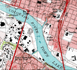
DRG Map


This DRG map is a USGS topographical map, reproduced and put onto a computer. It has many uses, for example, this could be a map for someone unfamiliar with the colorado area and wanting to explore. The map is of Colorado and includes many tourist attractions (the rivers, roads, and business locations).


http://www.tceq.state.tx.us/assets/public/gis/images/drg.gif
Posted by rls05g at 5:42 PM

No comments:

Post a Comment

Newer Post Older Post Home
Subscribe to: Post Comments (Atom)

Maps Maps Maps

Blog Archive

  • ▼  2008 (51)
    • ▼  December (50)
      • Star plot
      • Correlation Matrix
      • Similarity Matrix
      • Stem and Leaf Plot
      • Box plot
      • Histogram
      • Parallel Coordinate Graph
      • Triangular plots
      • Windrose
      • Climograph
      • Population Profile
      • Scatterplot
      • Index Value Plot
      • Lorenz curve
      • Bilateral Graph
      • Nominal Area Choropleth Map
      • Unstandardized Choropleth Map
      • Standardized Choropleth Map
      • Univariate choroplath map
      • Bivariate choropleth map
      • Range graded proportional circle map
      • Continuously variable proportional circle map
      • DOQQ
      • DEM
      • DRG Map
      • Isopleth
      • Isopachs
      • Isohyets
      • Isotach
      • Isobars
      • LIDAR
      • Doppler Radar
      • Black and White Aerial Photo
      • Infrared Aerial Photo
      • Cartographic Animation
      • Statistical Map
      • Cartogram
      • Flow Map
      • Isoline Map
      • Proportional Circle Map
      • Choropleth Map
      • Dot Distribution Map
      • Propaganda Map
      • Hypsometric Map
      • PLSS Map
      • Cadastral Map
      • Thematic Map
      • Topographic Map
      • Planimetric Map
      • Mental Map
    • ►  October (1)

About Me

rls05g
View my complete profile